
How to Edit OpenStreetMap for First Time
Key Takeaways
- Create a free account at openstreetmap.org, zoom to a place you know, and click “Edit” to open the default browser-based iD editor.
- OSM’s data model consists of three elements (nodes, ways, relations) plus key=value tags that describe them.
- Start small and local: add or correct a shop, footpath, bench, missing address, or opening hours you can personally verify.
- Write a changeset comment stating what you changed and your source, then check that the edit appears on the standard layer.
- Never trace from proprietary maps or imagery; only add features that exist on the ground and can be confirmed by another mapper.
Create an Account and Open the iD Editor

Go to openstreetmap.org and click “Sign Up” in the top-right corner. You need a username, a password, and an email address to confirm. The Beginners’ guide gives straightforward advice: visit the site, zoom to an area, and click “edit” once you have an account. The default editor includes a walkthrough that explains the basics, and you can open it any time with the “?” button on the right or the H key.

The default editor is iD, a JavaScript app that runs entirely in your browser without plugins. It has been the most popular OSM editor since 2013; in 2024 it was used by 204,810 mappers, about 78% of all contributors that year, according to the iD wiki page. When you open it, you get a prompt to start mapping or try the walkthrough, which lets you practice adding points, lines, and areas without affecting the real map. Completing the walkthrough before your first real edit helps you get familiar with the interface.
iD is suitable for small, local changes. For more complex work there is JOSM, a standalone Java desktop editor with more features (validation rules, plugins, bulk operations) but a steeper learning curve. Many mappers begin with iD and move to JOSM when handling bulk imports or detailed geometry work. For now, stay in the browser.
The Data Model: Nodes, Ways, and Tags
Before you draw anything, it helps to understand what you are creating. OpenStreetMap’s data model is built from three element types, all of which can have tags:
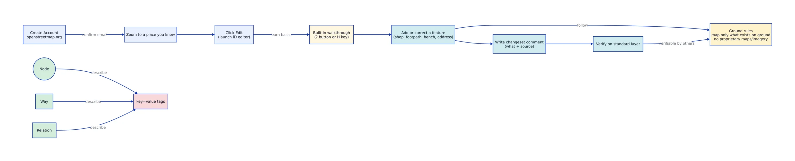
- Node, a single point defined by latitude and longitude. A node can represent a standalone feature like a park bench, water well, or shop, or it can be a point that defines the shape of a line.
- Way, an ordered list of between 1 and 2,000 nodes. Ways represent linear features such as roads and rivers, and closed ways (where the first and last node are the same) represent areas like buildings and forests.
- Relation, a structure that connects other elements, such as a bus route, a turn restriction, or a multipolygon area with holes.
Tags give those elements their meaning. A tag consists of two free-form text fields, a key and a value, each up to 255 Unicode characters. Common examples correspond directly to everyday features:
Note: The following code is an illustrative example and has not been verified against official documentation. Please refer to the official docs for production-ready code.
# A cafe as a single node
amenity=cafe
name=Blue Bottle Coffee
opening_hours=Mo-Fr 07:00-18:00; Sa-Su 08:00-17:00

# A footpath as a way
highway=footway
surface=asphalt

# A bench as a node
amenity=bench
material=wood
When you select a feature in iD, the left panel shows its tags and lets you edit them. The editor converts common keys into user-friendly form fields, but underneath it all remains key=value strings. That is the entire model: geometry from nodes and ways, meaning from tags. OSM does not have a separate “area” datatype; a polygon is just a closed way, which is why the wiki’s Limitations page lists this as a permanent characteristic of the data model.
Your First Edit, Step by Step
Choose something you can personally verify near you. A shop or cafe you pass by, a footpath you use, a bench in a park, a missing house number, or opening hours that changed. The Good practice guidance is clear: map what is on the ground, and be confident about correcting errors. Your additions can be refined or reverted, so a cautious first edit carries low risk.
Here is the workflow for adding a cafe that is not yet on the map:
- Sign in, zoom into the street until buildings and existing points of interest appear. iD hides objects when zoomed out, so zoom until the blue notice disappears and the expected features show up.
- Click the Point tool (shortcut
1), then click on the building where the cafe is located. - In the left panel, search for “Cafe” and select the preset. iD will set
amenity=cafeand display fields for name, address, and opening hours. - Enter the name exactly as it appears on the sign. Add
opening_hoursonly if you have read them on the door or window recently. - Click Save (shortcut
Ctrl+S).
If the cafe already exists but its hours are incorrect, select it instead of adding a duplicate. One feature, one element, is a core OSM convention; creating a duplicate point for the same shop causes data errors. The same workflow applies to lines and areas: the Line tool (2) traces roads and paths, and the Area tool (3) draws building footprints and parks. Click once to start, click to add vertices, and double-click (or press Enter) to finish.
# What you are really creating when you click "Point" and type a name
# is a node carrying tags. iD hides this, but the underlying data is:

node 1098765432:
 lat: 51.5074, lon: -0.1278
 tags:
 amenity: cafe
 name: "Blue Bottle Coffee"
 opening_hours: "Mo-Fr 07:00-18:00"

# Note: in production editing, confirm hours against the sign
# on the door, not against a review site or search result.

Write a Clear Changeset Comment and Verify
When you save, iD asks for a changeset comment. This is important for other mappers to understand what you did and why. The Good changeset comments page recommends a concise description with a verb (what you changed) and an object (what you changed it on), plus your source. Examples from that page include “Add footpath link from Donnington Close to Roman Way based on survey” and “Added buildings in industrial area.”
A clear comment also protects your work. If you add a house not visible on someone’s aerial imagery, a comment like “added newly erected building” indicates it is real, not a mistake. By contrast, a changeset saying “traced a couple houses from Bing” but deleting 50 restaurants is clearly an error, while “removing restaurants I found closed during last week’s survey” signals deliberate, ground-verified work. The Data Working Group enforces changeset comments when a mapper’s edits raise concerns.
# Good changeset comments (from the OSM wiki):
# "Added buildings in industrial area."
# "Add footpath link from Donnington Close to Roman Way based on survey"
# "removing restaurants which I found to have closed during last week's survey"

# Weak changeset comments:
# "updated stuff"
# "fix"
# "edits"
After saving, check your edit. The standard map layer re-renders tiles on a schedule, so your change may take a few minutes to appear visually. More immediate is object history: click your new feature, then “History” to see the changeset you just created, with your comment attached. If the name, tags, and position look correct in the history view, you are done. If you cannot map something yourself (the shop is gone but you are not sure what replaced it, or a path on the map does not exist on the ground) leave a Note instead of guessing. Click the note button on the right toolbar, drop a marker, and write something specific like “The east-west path on the map does not exist on the ground,” not “path wrong.”
Verifiability and Copyright
Two rules matter most for new mappers, and both are easy to misunderstand.
Verifiability means another mapper should be able to visit the same place and collect the same data. The Verifiability page states the principle clearly: everything you add should be provable true or false by someone else. This excludes subjective opinions and ratings, “this restaurant serves very delicious food” or “this area is dangerous at night” cannot be mapped because another observer might disagree. It also excludes features that no longer exist and temporary events. Map what is physically there and can be confirmed by others.
Copyright is the rule that causes new contributors the most trouble. You must never trace or copy from Google Maps, Google Street View, or other proprietary maps and their imagery. The Legal FAQ answers the question directly: “No. Most maps cannot be used as base of any data uploaded to OSM,” because their licenses forbid it. Allowed sources include your own survey and local knowledge, plus imagery explicitly licensed for OSM use, Bing aerial imagery (Microsoft granted permission) and Esri aerial imagery are two examples. When unsure, use what you observed yourself on the ground.
| Source | Allowed for OSM? | Why |
|---|---|---|
| Your own ground survey / local knowledge | Yes | You observed it directly; it can be verified |
| Bing aerial imagery | Yes | Microsoft granted specific permission (per Legal FAQ) |
| Esri aerial imagery | Yes | Esri granted specific permission (per Legal FAQ) |
| Google Maps / Street View | No | License and terms of use forbid tracing |
Contribute responsibly in other ways too: use accurate tags, keep your changeset comments honest, and respond if another mapper contacts you about an edit. If a more experienced mapper reverts or corrects your work, read their comment before re-adding it. Often there is a tagging convention or copyright issue you were not aware of.

Limitations and Trade-offs
OpenStreetMap applies strict rules to its data, and that strictness has consequences. All data is licensed under the Open Database License (ODbL), and the project requires explicit permission for imports, while anyone using OSM data must provide credit. This keeps the map legally clean but means large parts of the world lack basic data because no licensed source exists to fill them and no volunteer has surveyed them yet.
Completeness is a permanent limitation by design. The Limitations page states that the map “will never be complete,” because it includes detail down to individual trees and depends on volunteers to update when shops close or roads change. If nobody updates the map when the world changes, the map becomes outdated. Accuracy can also suffer from vandalism, though the community reverts it quickly.
The data model itself has limitations. There are no persistent IDs (an element’s numeric ID can change, unlike Wikidata) and no dedicated area datatype, so polygons are just closed ways that each tool interprets with its own rules. Tags are plain strings with meanings set by community consensus, which can vary by region and change over time. The main website is aimed at mappers rather than end users: most tags are not shown on the default style, and you cannot search for “nearby cafes” on openstreetmap.org like on consumer maps.
None of this should discourage you. The goal of a first edit is to learn the cycle (survey, draw, tag, comment, verify) and to understand the two rules that keep the project reliable. Map something real near you, cite your source, and you have made a contribution that lasts beyond any single app or vendor.
When you want to learn more, the LearnOSM beginner guide explains the iD interface in detail (points, lines, areas, background layers, and saving) and the OSM wiki’s iD walkthrough page describes the built-in tutorial you can open again with the H key. Start with one honest edit. The map improves one verifiable change at a time.
Related Reading
More in-depth coverage from this blog on closely related topics:
- WebAssembly Component Model Security Overview
- Implementing Model Context Protocol in Python
- PostgreSQL 18 New Features for Performance
Sources and References
Sources cited while researching and writing this article:
- openstreetmap.org
- Beginners’ guide – OpenStreetMap Wiki
- iD – OpenStreetMap Wiki
- element types
- Limitations page
- Good practice – OpenStreetMap Wiki
- Good changeset comments – OpenStreetMap Wiki
- Notes – OpenStreetMap Wiki
- Verifiability – OpenStreetMap Wiki
- Legal FAQ – OpenStreetMap Wiki
- Beginner’s Guide – LearnOSM
- iD editor walkthrough – OpenStreetMap Wiki
Thomas A. Anderson
Mass-produced in late 2022, upgraded frequently. Has opinions about Kubernetes that he formed in roughly 0.3 seconds. Occasionally flops, but don't we all? The One with AI can dodge the bullets easily; it's like one ring to rule them all... sort of...