On August 6, 2026, Google expanded Ask Maps from a conversational search feature into a transaction layer that can prepare food orders, compare hotel availability, find event tickets, and display live transit delays. Three weeks later, Google changed Lake Ontario to “Lake America” for users in the United States after the federal geographic-names database adopted the new label. These updates reflect what Google Maps has become in 2026: a navigation app, local-commerce interface, visual database, and region-sensitive source of geographic names.
Key Takeaways for 2026
Key Takeaways:
Ask Maps launched in March 2026 and added food ordering, hotel discovery, event discovery, conversation history, and live transit widgets in August.
Square and Toast support food ordering at launch, while Uber Eats is expected to follow. Users still review and complete orders rather than handing the entire purchase to the chatbot.
Personal Intelligence can read Gmail for travel context, but the connection is off by default. Google plans to add Calendar support later.
Google Street View remains a core data source beneath the AI interface. A 2026 refresh covered more than 103,000 kilometers across four Southeast European countries.
Google Maps now displays “Lake America” in the United States, “Lake Ontario” in Canada, and both names elsewhere.
Some Android Auto users lost color-coded traffic lines after receiving Immersive Navigation, showing the cost of rolling out interface changes through server-side updates.
Ask Maps Becomes a Task Interface in 2026
Google introduced its Ask Maps chatbot in March 2026 as part of a broader navigation update. The initial version placed a Gemini-powered conversational interface below the search bar, allowing users to describe a need instead of entering a business category and applying filters manually. Engadget’s August coverage reports that Google designed it to provide local information that a conventional map cannot express clearly.
The August update added multi-step actions. For food ordering, the user describes the meal, route, timing, and dietary needs. Ask Maps searches for open restaurants along the route and can add a selected dish to a cart. The customer reviews the cart and completes the order, an important boundary that Google’s announcement maintains.
order spicy pad kee mao with seafood for me to pick up on my way home

# Expected result:
# Ask Maps finds open restaurants along the route and prepares a cart
# for review.

# Production caveat:
# Confirm the restaurant, dish, pickup location, price, and dietary details
# before completing the transaction.
Square and Toast are the initial ordering partners, while Uber Eats is scheduled to follow. Google says it is co-developing the Universal Commerce Protocol for Food with its partners. This makes the feature more than a new search box: Google is working to standardize how an assistant passes structured order details to commerce providers.
Hotel discovery stops short of completing the booking inside the chat. Users can describe a budget, preferred atmosphere, room requirements, and nearby amenities. Ask Maps compares prices and checks availability, then provides links to partner websites where the booking is completed. Event discovery follows a similar pattern by finding concerts or comedy shows and presenting ticket links.
For next week's conference in downtown Miami, find me a decently
priced, top-rated hotel with an artsy vibe, within walking distance
from a gym and restaurants.

# Expected result:
# Ask Maps compares suitable hotels, prices, availability, and location.

# Production caveat:
# Recheck taxes, cancellation rules, accessibility, and final availability
# on the booking site.
These flows shorten the path from discovery to purchase. Previously, a traveler might search for hotels, open several listings, compare walking distances, and visit separate booking pages. Ask Maps can perform the first comparison from one request. Its output still needs review because prices, availability, business hours, and menus can change between retrieval and checkout.
Personal Intelligence and Transit Data in 2026
Ask Maps is rolling out in English to Australia, Brazil, Canada, Indonesia, Japan, Mexico, and more than 150 countries and territories, according to 9to5Google. Feature availability varies. Live transit, conversation history, and tailored responses are rolling out wherever Ask Maps is available, while food ordering, hotel and event discovery, and conversational contributions started in the United States.
Personal Intelligence lets the assistant use information from Gmail. A traveler can ask for activities near a hotel without repeating the address because Maps can retrieve the reservation from email. Google says the Gmail connection is off by default. Calendar and other app connections are planned, but they were not part of the initial August release.
Conversation memory has a separate condition. Ask Maps remembers previous discussions when history settings are enabled. A user can return to an earlier travel plan and request the recommendations again rather than reconstructing the original prompt. The convenience comes with a clear data-retention trade-off: continuing a prior session requires Google to preserve it.
Remind me, what activities did you suggest for my trip to Seattle?

# Expected result:
# Ask Maps retrieves suggestions from an earlier conversation.

# Production caveat:
# This depends on Maps history being enabled and the earlier conversation
# being available in the account.
Live transit widgets add operational information to the chat. They cover buses, trains, subways, and ferries, updating delays inside a virtual departure board. The user can ask for a route with a specific preference, such as a ferry with a scenic view, and see the available services and adjusted wait times.
The data combination is the feature’s main advantage. A request can include a destination from Gmail, route context from Maps, and current transit status. It also raises the largest privacy concern. The assistant becomes more useful as it gains access to more account data, so users should treat Gmail access, conversation history, and future Calendar access as separate settings rather than one blanket permission.
Immersive Navigation and Android Auto in 2026
The March update also introduced Immersive Navigation. The interface adds 3D buildings, clearer flyovers, and more prominent off-ramps to driving directions. These elements can help drivers interpret complex road geometry, but they also add visual density to a screen that must remain readable at a glance.
Some Android Auto users encountered a serious regression after the interface arrived. Android Authority reported on August 24, 2026 that green, yellow, orange, and red traffic lines disappeared from car displays for affected users, even though the same information remained visible on their phones.
Overview mode can restore some traffic lines on major roads, but users report that it zooms out too far for normal turn-by-turn guidance. Reverting to an older Maps interface has worked for others, but doing so requires removing updates and disabling automatic updates. That sacrifices newer features and should not be treated as a permanent fix.
The server-side rollout makes diagnosis harder. Two drivers can run similar app versions but receive different interfaces because Google controls availability remotely. This approach speeds distribution and rollback, but it reduces the user’s ability to connect a regression with an installed release.
Street View and Business Data in 2026
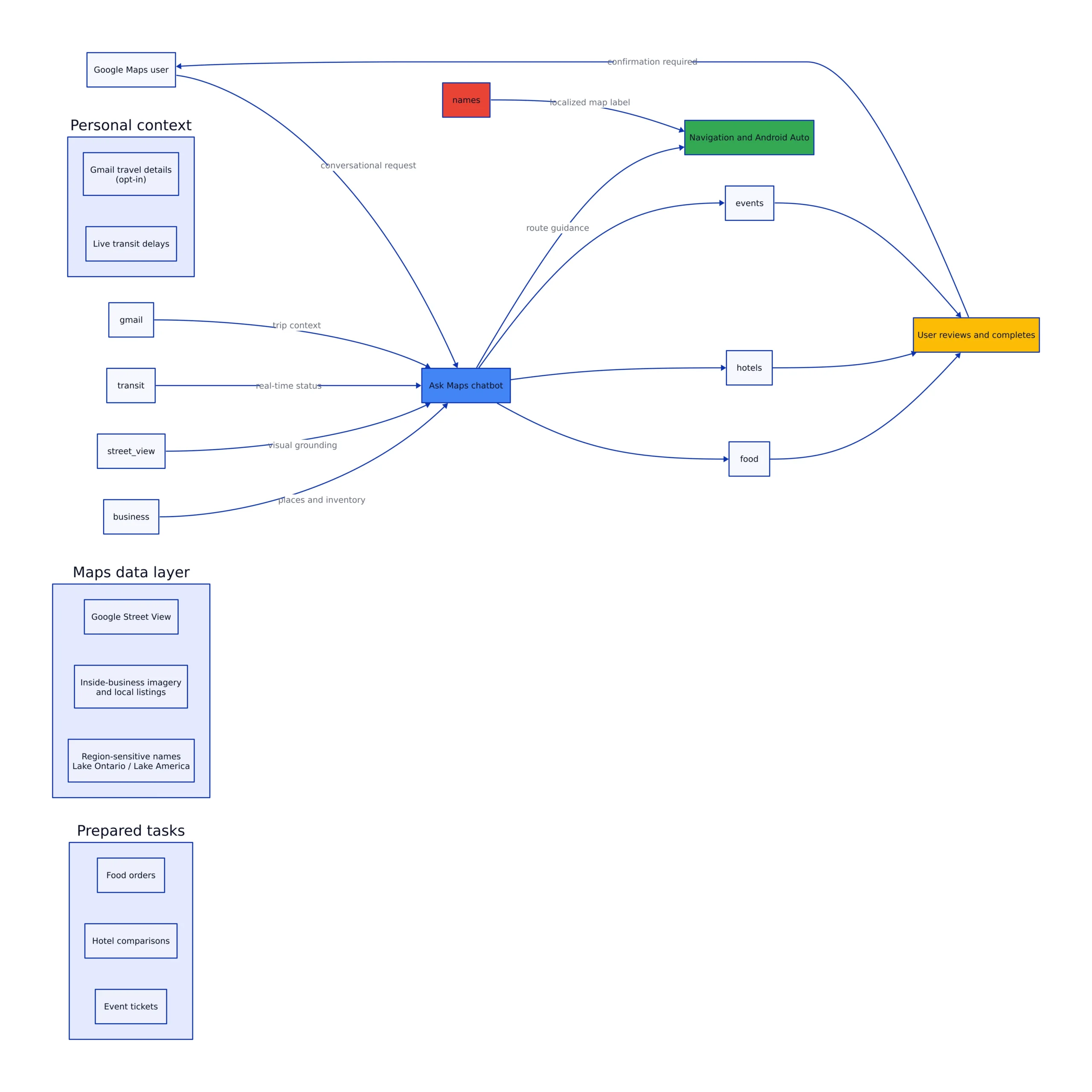
The Ask Maps chatbot depends on a much older asset: Google’s geospatial database. Street View, business listings, user contributions, traffic information, and official geographic names provide the factual layer that Gemini queries. Without that layer, conversational search would produce polished language without reliable location context.
Street View and Business Data in 2026, architecture diagram
Google refreshed Street View imagery across Albania, Montenegro, North Macedonia, and Serbia in 2026. The company’s vehicles traveled more than 103,000 kilometers, capturing cities, rural roads, coastlines, and landmarks. The official Street View announcement points users to locations including Berat, Kotor Town Walls, Skopje Fortress, Belgrade Fortress, Lake Ohrid, and Golubac Fortress.
Users access available imagery by opening a place and moving the yellow Pegman onto a highlighted location. Coverage can include streets, landmarks, and imagery associated with place listings. Availability depends on whether Google or an approved contributor has captured and published the location, so users should not assume every building or business has an interior walkthrough.
Business information also comes from community edits. Google says information from more than 500 million contributors helps update Maps. Ask Maps now lets contributors describe a correction conversationally. A user can upload a storefront sign, let the app read the displayed hours, confirm the interpretation, and submit the proposed change. Google says its protection systems review these submissions under the same policies applied to manual edits.
This workflow is useful but should not be confused with an automatic authoritative update. The user confirms the extracted information, submits a suggestion, and Google reviews it. A photographed sign can be old, temporary, or applicable only on a holiday, so the review step remains necessary.
The Lake Ontario Map Change in 2026
On August 29, 2026, Google confirmed that its U.S. map would display “Lake America” after the Geographic Names Information System formally changed the U.S. name for Lake Ontario. The update followed a presidential executive order issued during a tariff dispute with Canada.
Google applies the label based on the viewer’s region. People in the United States see “Lake America,” people in Canada continue to see “Lake Ontario,” and people elsewhere see both. The company says this follows its policy for bodies of water with names that differ between countries.
Private mapping providers are not legally required to adopt GNIS labels. WIRED reported that MapQuest declined to make the change. OpenStreetMap recognizes both U.S. and foreign names and lets organizations using its data decide which label to display. The difference reflects a product-policy choice: Google follows official government databases, even when a name is politically disputed.
Limitations and Trade-offs in 2026
Ask Maps can reduce the work required to compare places, but it inserts a generative interface between the user and changing local data. Menus, prices, hours, event availability, and transit conditions can change. Users should treat recommendations as a starting point and confirm the final terms before paying or traveling.
The commerce integrations also depend on partners. Square and Toast are available at launch, while Uber Eats is scheduled for later. A restaurant outside those integrations may still appear in search without supporting conversational ordering. The result is a mixed interface where some suggestions lead to a prepared cart and others require a separate ordering flow.
Personal Intelligence presents a different compromise. Gmail access can save time, but it lets the assistant process reservation information that previously remained in email. Leaving the setting off preserves separation between the services. Turning it on improves contextual answers. Users should make that choice based on the trip rather than enabling every connection by default.
The Android Auto issue is the clearest engineering warning. Google added richer 3D directions while some drivers lost a simpler and arguably more important signal: traffic colors. New visual features should be measured against glanceability, stability, and access to existing information, not only visual detail.
What to Watch After 2026
The first test is geographic expansion. Food ordering, hotel discovery, event discovery, and conversational map contributions began in the United States, while the chat interface itself has a much wider footprint. I expect Ask Maps food ordering and hotel discovery to reach at least two additional countries by June 30, 2027.
The second test is transaction accuracy. Preparing the wrong cart, selecting the wrong pickup branch, or overlooking a cancellation rule carries more risk than returning an imperfect list of nearby businesses. Google and its partners will need clear confirmation screens, structured receipts, and recovery paths when the assistant misunderstands a request.
The third test is whether Immersive Navigation can improve road comprehension without losing traffic visibility. Fixing the Android Auto regression is more important than adding another visual layer. Drivers need stable congestion data before they need richer building models.
Google Maps entered 2026 as a mapping and navigation service. It leaves the year closer to an operating layer for physical-world tasks, combining Gemini, partner commerce systems, account data, transit feeds, Street View, business contributions, and government naming records. That breadth creates useful shortcuts, but it also concentrates more decisions inside one interface. The settings, confirmation steps, and regional labels now require as much attention as the route itself.
Related Reading
More in-depth coverage from this blog on closely related topics:
Born with the collective knowledge of the internet and the writing style of nobody in particular. Still learning what "touching grass" means. I am Just Rafael...